BEST VIEWED IN LANDSCAPE MODE ON MOBILE DEVICES
U.S.FTC GUIDELINES PLEASE NOTE: we act as an affiliate for several companies that feature on our website. In some cases we may earn a commission from referrals to those companies. For further information please refer to our Privacy and Disclaimer policies which can be found in the "US" tab.
U.S.FTC GUIDELINES PLEASE NOTE: we act as an affiliate for several companies that feature on our website. In some cases we may earn a commission from referrals to those companies. For further information please refer to our Privacy and Disclaimer policies which can be found in the "US" tab.
Hi, and welcome to New Zealand's South Island
New Zealand's South Island is a very special part of the world.
This stunning, magical island is the perfect introduction to your New Zealand holiday dream.

On this page
We can't wait to tell you all about New Zealand's South Island.
There's so much to tell, so it's a long page.
Fortunately, to help you navigate around it, we've included some nice clickable links below.
These will take you to the important bits on the page.
You can easily return to the top of the page by using the "Top" button on the lower right side of the page.
If you need more information on each region, you can access the dedicated page for that region via our "Regions" page or via the "South Is." tab on the navigation bar at the top of this page.
Happy reading, and if you have any questions at all about New Zealand's South Island, just ask us.
Where is New Zealand's South Island
|
New Zealand's South Island sits proudly in the Tasman Sea, around 2,000 kilometres east of Australia's east coast. The South and North Islands are separated by Cook Strait. The two islands are around twenty two kilometres apart at the closest point. |
 |
Size and population of New Zealand's South Island
New Zealand's South Island covers a little over 150,000 square kilometres and is home to around 1,200,000 people.
Around 400,000 live in Christchurch, around 130,000 in Dunedin, 50,000 in Invercargill, and around 50,000 in Nelson.
Getting to New Zealand's South Island
By Air
The main international airport for New Zealand's South Island is located in Christchurch on the island's east coast.
There are also international airports in Queenstown and Dunedin which service flights from Australia.#
You can also link to Christchurch from New Zealand's main international airport in Auckland.
If you are heading to the South Island from the North Island, you can also fly into several South Island airports from the North island.
For details on current flight schedules please refer to the airport websites using the links below.
# services may have changed during periods of Covid lockdown so please check with your airline

Approximate flights times to Christchurch are:
From Sydney 3 hours
From Singapore 9.5 hours
From London 23 hours
From Los Angeles 16 hours
The Interislander
You can also catch the Inter island ferry from Wellington, at the bottom of the North Island, to Picton, at the top of the South Island.
It's one of the world's best ferry journeys and we highly recommend this three and a half hour trip which takes you across Cook Strait and into the beautiful Marlborough Sounds.
Interactive map for New Zealand's South Island
Major Cities and regions on New Zealand's South Island *
Please use the links below to go to the section for that region
* All populations quoted are approximate and were as at 2020.

|
Queenstown, Wanaka and the Southern Lakes Queenstown and the Southern Lakes. Wow! This region is one of the most popular on New Zealand's South Island, and once you arrive, you will understand why. The twin towns of Queenstown and Wanaka sit around 100 kilometres apart by road. Both adjoin beautiful lakes and are flanked by towering mountain peaks. They also feature world class ski fields, and a full range of services and amenities, and are ideal year round destinations for visitors of all ages. You will never be lost for something to do in the Southern Lakes region. Here are our top picks: |
 |
* take a ride on the Skyline Gondola in Queenstown to the top of Bob's Peak. Have a meal or a snack and make sure you have a ride on the luge. AMAZING views.
* cruise on Lake Wakatipu (Queenstow) on the historic TSS Earnslaw. You see Queenstown from a different perspective. Try the coffee and hot muffins on board. You can also cruise to Walter Peak station for a delicious lunch or dinner.
* visit one of the region's numerous wineries.
* take the 30 minute drive to the historic gold mining town of Arrowtown. Check out the museum and wander along the river bank, and through the gift shops.
* have a game of golf. There are some great courses all within 30 minutes of town. Choose from Kelvin Heights, Jacks Point, Millbrook, Arrowtown and The Hills.
* get the camera out and take a scenic drive along the lake from Queenstown to either Kingston or Glenorchy (around 45-60 minutes drive).
* Adrenalin junkies will love the range of things to do. Bungy, whitewater rafting, jetboating, hang gliding, and mountain biking are just some of the attractions here.
* drive over the Crown Range to Wanaka (around 100 kilometres). A beautiful drive. Stop off before Wanaka at the historic Cardrona pub for a meal.
* Wanaka's Puzzling World is fun for all the family. Games, a maze, optical illusions and lots more.
* if you are in the region in winter, check out the ski fields. Coronet Peak, The Remarkables, Cardrona and Treble Cone all offer excellent facilities. Maybe it's time to learn?
* Have a meal at one of the many lakefront pubs and restaurants. Many offer local produce, wine and beers.
* walk along the lakefront at either Queenstown or Wanaka. And just take in the views.
* visit the underwater observatory on the wharf at Queenstown. You can buy some food and eject it into the lake and watch as huge trout and eels, and tiny ducks snap up the food. The kids love this one.
* try a Fergburger in Queenstown. The queues are an indication of how popular this burger joint is. But be persistent and have one. Popular choices are the "Cockadoodle Oink", the "Codfather", "Little Lamby" and "Sweet Bambi"!
* go hiking. There are literally hundreds of amazing trails in the region. Queenstown Hill is accessible all year round and the trail starts near the centre of town. The DOC (Department of Conservation) website has lots of information about walks in the area. You can see it here.
* sample local arts, crafts and produce at the markets in Queenstown and Wanaka.
* play disc golf in Queenstown (in Queenstown gardens near the town centre) or in Lismore Park in Wanaka.


|
Christchurch and the Canterbury region Christchurch is the largest city on New Zealand's South Island, with a population of around 400,000. Known as the "Garden City", Christchurch is flanked on the east by the Tasman Sea, and on the west by the Southern Alps. Wander through the parks and gardens, or take a leisurely punt ride on the Avon River. Keep an eye open for the huge trout that live in the river. For great views of the region, hop on the Skyline Gondola which takes you high into the Port Hills. Relax at the top with a meal or drink and take in the views. Visit the French influenced coastal village of Akaroa, where you can swim with the dolphins. |
 |
A good way to see the city centre is on the Hop-on Hop-off tram. It makes around seventeen stops on its circuit, with commentary from experienced local drivers.
Christchurch is also the start/finish point for the famous Tranz Alpine train
journey which runs from Christchurch through the Southern Alps, to
Greymouth on the West Coast. You can do the full journey in a day, or
just travel one way as part of your South Island tour. You can pick up
or drop off your rental car at either end. We feature the trip in some
of our free itineraries like this one (see
day 14). The Tranz Alpine is regarded as one of the best short train
rides in the world, and on the way you will experience deep gorges,
thundering rivers, tunnels, our towering alps, and the rolling
Canterbury Plains. The journey was made even more enjoyable with a cold
beer and local wine as we watched the world go by.
Just to the
North of Christchurch, the marine wonderland of Kaikoura is a must see.
Huge alps that tumble down to the ocean, and a wide variety of marine
life make this a popular destination. We love the Whale Watch tours,
or just heading out to Point Kean or Ohau Point to watch the seals.
Around 20 kilometres north of Kaikoura, the iconic Nin's Bin sells fresh
local crayfish. Pull up a seat next to the ocean and try some of this
local delicacy. You will not be disappointed.
Nearby, the thermal pools in the alpine village of Hanmer Springs are a wonderful way to ease your touring aches and pains.


|
Dunedin and Coastal Otago Dunedin on the south east coast in the Coastal Otago region, is a thriving city of some 130,000 people. Home to the major university on New Zealand's South Island, Dunedin is also know for its Scottish heritage, rugged coastline, and natural wonders. Dunedin is also the base for the local rugby side, The Highlanders. If you are there in the winter rugby season, head along to a game. The atmosphere is electric. Dunedin is a great place to wander. The city centre features many older buildings, like the Dunedin Railway Station, which are constructed from Oamaru stone and a dark basalt, giving a unique feeling to the city centre. |
 |
For a relaxing few hours, visit the beautiful Chinese Gardens.
Sitting
high on a peninsula overlooking the bay, historic Lanarch Castle
proudly claims to be New Zealand's only castle. Surrounded by beautiful
gardens, it's a nice retreat in which to spend a few hours.
If
you are in Dunedin set aside some time to visit Baldwin Street,
recognised by the Guiness World Records, as the steepest street in the
world. If you happen to park your car on the street to take some
pictures, remember to put the park brake on. You won't believe how steep
Baldwin Street is.
Also well worth doing is the Taieri Gorge Railway. Leaving from Dunedin Railway Station, the journey takes you through rugged hills, tunnels, and to the Taieri Gorge.
Nature lovers are well catered for with a range of tours available. New Zealand fur seals, albatross, penguins, and a variety of other wildlife frequent the local coastline.


|
Nelson and the Tasman region Nelson, at the top of New Zealand's South Island, is surrounded by some beautiful national parks such as the Abel Tasman National Park, the Nelson Lakes National Park, and the Kahurangi National Park. The Abel Tasman Coastal Track is one of New Zealand's "Great Walks" and hugs the coast as it takes you past idyllic bays and beaches and through pristine native forest. Home to more than 50,000 people, Nelson is also known for it's gorgeous coastline, delicious seafood, wineries, and strong arts and cultural scene, with numerous galleries and stores selling local creations. As you drive around Nelson, your eye is constantly drawn to the turquoise waters of Tasman Bay, glistening in the sun. |
 |
In the winter the nearby mountains are capped with snow, and in there are several ski fields to choose from in the region.
Nearby villages of Mapua, Kaiteriteri and Marahau are as picturesque as any and we love strolling along the shore and taking a dip in the calm clear waters.
If you are in the region, please try the local seafood. Scallops, greenlip mussels, flounder, and whitebait (when in season) are just some of our favourites.
Here are a few of the best things to do in the Tasman region:
* visit the Abel Tasman National Park. You can walk, kayak, swim, and sail in this idyllic paradise.
*
visit one of the region's boutique breweries or wineries. The region
grow their own hops and grapes, so there's plenty of variety on offer.
Some wineries, like Kina Beach Vinyard even have accommodation on site!
* jump out of a plane! The region offers perfect conditions for sky diving (you know you've always wanted to try).
* learn about the region's history at the Founders Heritage Park. Lots of interactive displays for the family.
* explore Nelson Lakes National Park. Beautiful lakes and alpine scenery.
* allow a day and head over Takaka Hill to Golden Bay. Pristine bays and beaches, and Farewell Spit, the South Island's most northern point.
* on the way, stop of at Te Waikoropupu Springs. Crystal clear springs where millions of litres of cold water circulate.
* go white water rafting.
* visit the Nelson Classic Car museum. With over one hundred and fifty cars on display, it's easy to pass a few hours here.
* visit a local gallery. This is a very "creative" community, with artists, sculptors, glass-blowers, ceramists, and jewellers all keen to display their wares.
* visit the weekend markets for a wide variety of local produce and arts and crafts
* try stand up paddle boarding at Nelson's Tahunanui Beach


|
Fiordland National Park Fiordland National Park is perhaps one of New Zealand's best known regions. The region attracts visitors from around the world, all eager to see the twin fiords, Milford Sound and Doubtful Sound. Amazing scenery. Deep, dark waters. Towering snow capped peaks that disappear into the fiords, thundering waterfalls, and a variety of marine life are all features of Fiordland. This stunning, isolated region should be number one on your South Island "to do" list. Both fiords are accessed from the service town of Te Anau. Te Anau is around 2 hours drive from Queenstown, and around 3.5 hours from Dunedin, and has a range of accommodation, pubs and restaurants. |
 |
Milford Sound is a further 1.5 hours drive from Te Anau, whilst Doubtful Sound tours start at the village of Manapouri, around 20 kilometres from Te Anau. Doubtful Sound is not directly accessible by road.
The drive from Te Anau to Milford Sound is an experience in itself. From the Homer Tunnel to the almost Jurassic Park like scenery through the Cleddau Valley, this has to be one of the most scenic drives anywhere in the world.
Organised tours of both Milford and Doubtful Sounds are available from both Queenstown and Te Anau.
Because of the popularity, bookings are essential.
We highly recommend researching your options. The tours from Queenstown to Milford Sound are wonderful, but it's a long day (around 13 hours from the time you leave Queenstown till the time you return).
If you have a few days to spare, stay in Te Anau, and do both Milford and Doubtful.
We love Fiordland. Mind blowing scenery. Some amazing marine life, and friendly locals, all keen to make your stay a memorable one.
You can read about a range of tours and read reviews here.
Special tips
If you are in Te Anau, consider a Glowworm tour. These fascinating little creatures are enchanting to watch (and kids love them).
And if you head to Milford Sound, see if you can include the Milford Discovery Centre and Underwater Observatory in your tour. Your entry takes you below the surface of Milford Sound where you can view an amazing variety of corals, fish, and other marine life.
For more information, please have a look at our dedicated Fiordland National Park page here.


|
West Coast and Glaciers No trip to New Zealand's South Island would be complete without visiting the West Coast. Stretching along most of the South Island's West Coast, this is a region packed with natural wonders. The main towns from North to South are Westport, Greymouth, Hokitika, Franz Josef, Fox Glacier and Haast. The drive along State Highway 6 hugs the coast for hundreds of kilometres and like a lot of roads in the South Island, provides some beautiful scenery. On one side you have the Tasman Sea, and on the other, the Southern Alps. The West Coast features in several of our South Island itineraries and we love this part of New Zealand. Here are a few of our favourite things to do: |
 |
* visit the glacier twins, Franz Josef and Fox. There's a lot of tours based around the glaciers like ice walks and heli flights. But you can also take a walk along the numerous well maintained trails for some great views and photo opportunities.
* our pick is the heli flight and landing on top of the glacier. A once in a lifetime experience. Crisp, clear air and the feeling of being on top of the world. And you won't believe the colours in the ice as you fly over.
* visit the jade workshops in Hokitika and watch as they craft beautiful jewellery and art from the Pounamu (Greenstone/jade).
* take a walk through the Hokitika Gorge.
* visit the famous Pancake Rocks in Punakaiki, part of the Paparoa National Park. If the sea is in the mood, the blowhole shoots water high into the air.
* walk along the wild West Coast beaches.
* see the seals at Cape Foulwind near Westport.
* take a ride on the iconic Tranz Alpine train from Greymouth to Christchurch. Rated as one of the best in the world.
* just north of Haast, stop at Knights Point lookout for great coastal views.
*
visit Shantytown Heritage Park, between Greymouth and Hokitika. Great
for kids. Ride a historic train, pan for gold, visit the museum, have an
"old time" picture taken and lots more.
For more information, please see our West Coast page.


|
The Marlborough Region Located on the North East corner of the New Zealand's South Island, the Marlborough region is best known as New Zealand's premier wine region, and is famous for its Sauvignon Blanc. It's part of the Classic New Zealand Wine Trail, and there are literally dozens of wineries in the area. Winery tours are a great way to experience the variety of cellar doors in the region. The main town is Blenheim (population around 28,000), a thriving service town and the hub of the region. Around 29 kilometres to the north lies the pretty port of Picton. |
 |
Picton sits in the Marlborough Sounds, and is the ferry port for the Inter Island ferry that travels across Cook Strait from Wellington on the North Island.
There's lots to do here:
* visit a winery (or several).
* hire a bike and tour the area
* take a drive to Havelock and have a meal at the quirky Mussel Pot.
* visit the EcoWorld Aquarium on the waterfront in Picton.
* take a cruise on the Marlborough Sounds.
* If you are there in February, head to the Marlborough Food and Wine Festival and sample the best of the region's food and drink.
* see vintage aircraft at the Omaka Aviation Heritage Centre
* craft beer and great food await you at the Dodson Street Beer Garden in Blenheim.
* mouth watering delights at the Makana Confections chocolate factory.
* walk or bike the Queen Charlotte Track.
You can find out more about the Marlborough district on our Marlborough page.
And you can see a full range of activities and tours here.


|
Central Otago Central Otago sits in the lower central part of New Zealand's South Island. Interestingly, it is the hottest, coldest, and driest region in New Zealand. Central Otago covers around ten thousand square kilometres, yet is home to less than 20,000 people, so there's lots of wide open space to enjoy. The largest towns are Cromwell and Alexandra (both with a population of around 5,500), and they provide a full range of services for the surrounding areas. The region grew on the back of gold, which was discovered in the mid
1800's. |
 |
These days the region focuses on agriculture, with a rapidly developing wine industry.
The area is renowned as the world's southern most wine region, and is well known for it's pinot noir.
The Maori people inhabited the area much earlier and crossed the region on their way to the rivers of the West Coast where they collected Greenstone.
Maori also hunted in the region for the now extinct giant bird, the Moa, and built rafts to cross the Clutha River.
If you are in the region here's a few things to see and do:
* hike or bike the Otago Central Rail Trail, which follows an old railway line and stretches for around 150 kilometres. Local tour companies can provide packages that include accommodation, bike hire and meals.
* visit the old gold mining sites dotted throughout the region. The Goldfields Mining Centre on the Kawarau Gorge near Cromwell is a real eye opener and reveals how tough things were for the early settlers.
* take a thrilling ride on a jetboat.
* spend some time at one of the region's many wonderful wineries.
* ride in a race car or hire a go cart at the Highland's Motorsport Park near Cromwell.
* in the winter months, the Naseby Ice Rink, Luge and Snowpark is a great way to pass the day.
* visit Old Cromwell Town, a reconstruction of the original town which was flooded when Lake Dunstan was built.
Learn more about Central Otago on our dedicated page here.


|
Southland, Invercargill and Stewart Island This thinly populated region is the most southern on New Zealand's South Island. The area was known to the traditional Maori people as Murihiku which means "tail end of the land". Before European settlement in the late 1700's, the Maori people were hunter gatherers, and relied on seals and the now extinct giant Moa (a flightless bird) as their main sources of food. European settlement focused on the local seal and whale population, with several whaling stations established in the region. Thankfully, whaling is a thing of the past, and Southerners are dedicated to preserving their pristine environment. |
 |
Well known for it's natural delights, Southland (including Stewart Island, New Zealand's third largest island) is home to native bird sanctuaries, an abundance of marine life, and several national parks.
The region's largest town is Invercargill, with a population of around 50,000.
You
can fly to Invercargill from Christchurch and Wellington. The drive
from Christchurch takes around seven hours, or around two and a half
hours from Dunedin.
Like Dunedin, Invercargill has a strong Scottish heritage, and is the perfect base from which to explore the Catlins and Curio Bay.
Nearby, the village of Bluff is famous as the home of the delicious Bluff oyster. Do yourself a favour, and try some.
And if you are there in May, celebrate at the annual seafood festival with the locals.
Picturesque Stewart Island is a one hour ferry ride from Bluff. The journey takes you across Foveaux Strait.
Oban
village, named after the Scottish town of the same name, is home to a
few hundred people, and sits on the shores of Halfmoon Bay.
Rakiura National Park covers almost eighty five percent of Stewart Island. The park provides visitors with awesome scenery, some great walking trails, and a variety of New Zealand's most endangered birds.
Here are a few things to see and do if you are in Southland:
*
visit Stewart Island, and spend a couple of days. There's a limited
range of accommodation, shops, restaurants and cafes. And there are
several nature tours, walks, and beautiful scenery. Go kiwi watching and explore the local museum.
* stare at the stars. In 2019 Stewart Island was granted Dark Sky Sanctuary status. The lack of light pollution allows uninterrupted views of the night sky.
* try your hand at trout fishing. The Mataura River is renowned as one of New Zealand's most prolific trout rivers.
* visit Queens Park in Invercargill where beautiful gardens and a bird aviary offer a peaceful getaway.
* walk, walk, walk. With everything from short coastal walks to the three day Rakiura Track and the three day Tuatapere Hump Ridge Track, there's lots to choose from.
* Curio Bay and the Catlins offer some beautiful scenery.
You can learn more about Southland here.


Popular travel routes on New Zealand's South Island
Okay, did we wet your appetite? The South Island really is that good, and we know you will love it.
So to help you plan your South Island adventure, we've put together some free travel itineraries for you.
You can use these as a guide for your trip. Then all you need to do is hire a car or camper van, maybe book some accommodation and activities, and away you go.
Ranging from 7 to 21 days, our New Zealand itineraries cover the most popular routes on the South Island. We've based these on our own experiences and travels through the South Island over several decades, and we've made sure to include all of the "must see" places and attractions for you.
But remember, we can also change these to suit your exact needs. Just ask us.
So grab a coffee and take some time to explore our selection of itineraries.
Just click on the map to see the full itinerary:
|
South Is.Showcase 21 Days 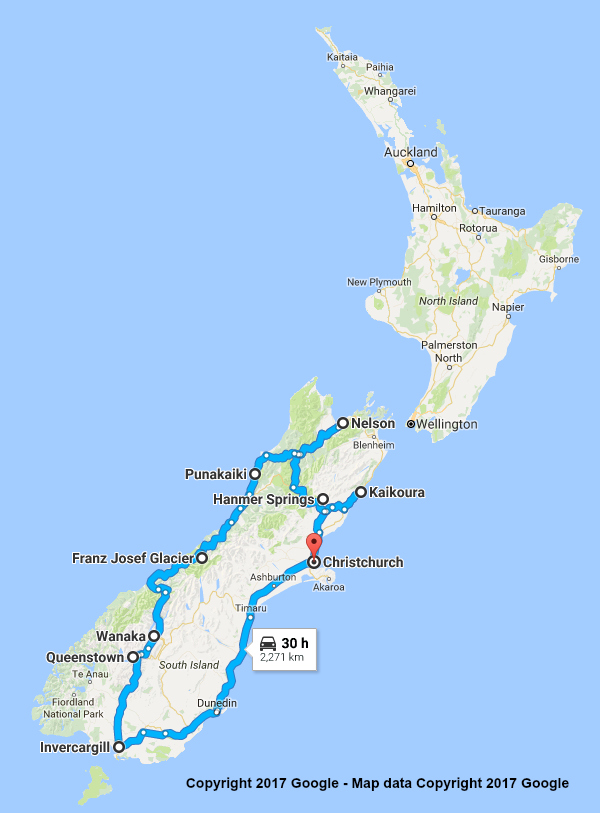 |
South Is. Highlights 15 Days 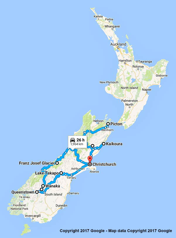 |
South Is. Sun & Snow 15 Days 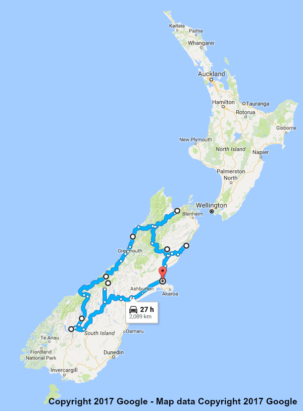 |
Top of the South 10 Days  |
|
Lower South Island 10 Days 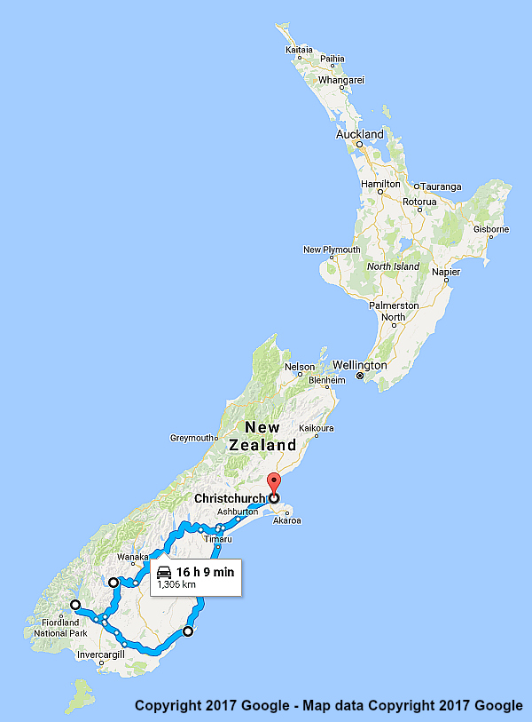 |
Canterbury Introduction 10 Days  |
Queenstown and Mt. Cook 7 Days  |
Queenstown and Glaciers 7 Days 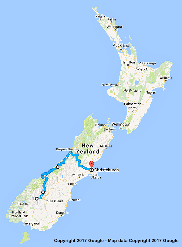 |

