BEST VIEWED IN LANDSCAPE MODE ON MOBILE DEVICES
U.S.FTC GUIDELINES PLEASE NOTE: we act as an affiliate for several companies that feature on our website. In some cases we may earn a commission from referrals to those companies. For further information please refer to our Privacy and Disclaimer policies which can be found in the "US" tab.
U.S.FTC GUIDELINES PLEASE NOTE: we act as an affiliate for several companies that feature on our website. In some cases we may earn a commission from referrals to those companies. For further information please refer to our Privacy and Disclaimer policies which can be found in the "US" tab.
New Zealand's North Island
New Zealand's North Island is right here, waiting for you.
Rich in history, Maori cultural delights, and natural beauty, New Zealand's North Island is an amazing place to spend a few weeks.

On this page
We've got so much to tell you about New Zealand's North Island.
That means that this is a long page.
But no need to worry, we've added some quick links below to help you navigate around.
And if you need to return to the top of the page, just click on the "Top" button on the lower right side of the page.
This page is a bit of a condensed collection of information about New Zealand's North Island, but we have a lot more detailed information on each North Island region which you can access from the North Island tab in the menu at the top of the page, or by clicking here.
So grab yourself a coffee, and enjoy New Zealand's North Island. And of course if you have any questions, just ask us.
Where is New Zealand's North Island (no, it's not part of Australia)
|
New Zealand's North Island is located in the Tasman Sea, and is about 2,000 kilometres to the east of Australia's east coast (around three hours flight time from Sydney or Brisbane). The South and North Islands are separated by Cook Strait. The North and South islands are quite close, and at the narrowest point, they are around twenty two kilometres apart. |
 |
How big and how many people in New Zealand's North Island *
New Zealand's North Island covers a little over 114,000 square kilometres and is home to around 3,700,000 people.
Around 1,700,000 live in Auckland (New Zealand's largest city), around 530,000 in Wellington (New Zealand's Capital), Hamilton around 150,000, Tauranga about 110,000, Rotorua 66,000, and Palmerston North around 75,000.
* All populations quoted are approximate and were as at 2020.
Getting to New Zealand's North Island
Flying
Our main international airport is located in Auckland.
International airports with limited services are also located in Wellington, Hamilton, and Palmerston North.#
You can also fly into several North Island regional airports from Christchurch on the South island.
For details on current flight schedules please refer to the airport websites using the links below.
# services may have changed during periods of Covid lockdown so please check with your airline

Approximate flights times to Auckland are:
From Sydney 3 hours
From Singapore 9.5 hours
From London 23 hours
From Los Angeles 16 hours
The Interislander
If you are lucky enough to be spending time on both of our beautiful islands, we can highly recommend the Inter island ferry from Wellington, at the bottom of New Zealand's North Island, to Picton, at the top of the South Island.
Rated as one of the world's best ferry journeys, it crosses Cook Strait and into the beautiful Marlborough Sounds.
Try our interactive Google map for New Zealand's North Island
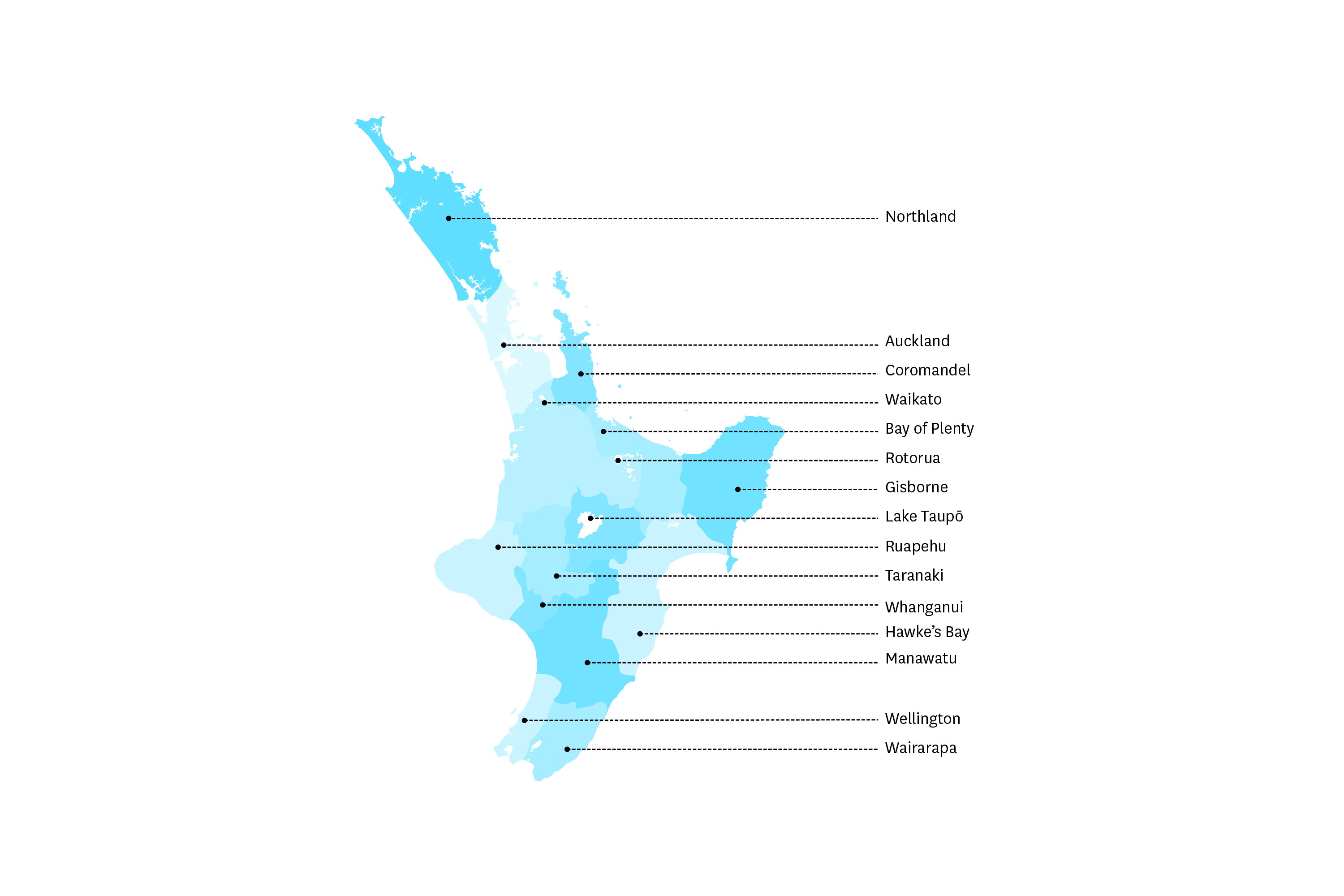
Major Cities and regions on New Zealand's North Island
Please use the links below to go to the section for that region
|
Auckland, New Zealand's largest city Auckland is a bustling, vibrant city, located towards the top of New Zealand's North Island. Flanked by two idyllic harbours, much of life here revolves around water based activities. But there's so much more to Auckland. It's a culturally significant place, with a strong Maori influence. The Maori know Auckland as Tamaki-Makau-Rau, which translates to 'the maiden with a hundred suitors', and history tells us that at one stage the region was home to some eighteen tribes. |
 |
There's so much to do here, and here's a few suggestions:
* catch the ferry to Waiheke Island. Well known for it's red wines and fine food, Waiheke is a great place to spend the day.
* take the fast elevator to the top of Auckland's Sky Tower. At 328 metres, the views from the top are superb. For an extra thrill, you can even take the "Skywalk" around the outside, or the "Skyjump".
* visit Kelly Tarlton's Sea Life and Underwater Aquarium.
* Bungy off the Auckland Harbour Bridge.
* take a trip to the famous Waitomo Caves, around two hours drive from Auckland.
* visit the region's LOTR sites.
* cruise on our beautiful harbour.
* wander through our Botanic Gardens, home to over 10,000 plants and covering 64 hectares.
* Auckland zoo houses over 150 species in an open range environment.
* take in the sights on one of the many walks. Our Coast to Coast Walkway takes around four hours and covers thirteen kilometres from central Queen Street to Onehunga.


|
Wellington, our cosmopolitan capital Wellington, New Zealand's capital, is located at the bottom of New Zealand's North Island. It's a thriving city of some 500,000 residents, located on a beautiful harbour. Packed with bars, pubs, cafes and restaurants, Wellington has a real cafe culture. Wellington is also the North Island departure/arrival point for the Interislander ferry which sails between Welington and Picton, on the South Island. If you are in Wellington here's a few suggestions for things to do: |
 |
* visit the Weta Workshops. Creators of some famous movie characters and sets (including the LOTR), it's a fascinating place.
* our number one is TePapa, the National Museum of New Zealand. Filled with art works and exhibits, it gives a remarkable insight to New Zealand culture and history.
* take the ride up Kelburn Hill on the iconic Wellington cable car.
* relax with a stroll through our botanic gardens.
* dine harbourside at one of the many eateries.
* explore Zealandia, our own city centre wildlife sanctuary.
* head around 80 kilometres north to the Martinborough vinyards.
* if time is limited take a guided tour of Wellington.
* go Kiwi spotting on an overnight "glamping" tour on Kapiti Island - highly recommended.
You can learn more about Wellington here.


|
Rotorua Rotorua is centrally located on New Zealand's North Island, around three hours drive south of Auckland. Rotorua should be on any North Island itinerary, and is perhaps best known for two reasons. Firstly, it's regarded as the home of New Zealand's thermal wonders. And secondly, Rotorua proudly showcases New Zealand's amazing Maori heritage. Rotorua sits on the shores of Lake Rotorua, the North Island's second largest lake, covering around 80 square kilometres. Here's a few of our top picks for things to do in Rotorua: |
 |
* take a stroll along the shores of Lake Rotorua.
* learn about our traditional Maori people at one of the local villages such as Whakarewarewa or Tamaki Maori Village.
* visit one of the local thermal areas like Wai-o-tapu, Hell's Gate and Te Puia.
* wander through the treetops at the Redwood Forest Treewalk.
* for wonderful views, catch the Skyline Gondola.
* visit the famous Hobbiton movie set.
For more information on Rotorua, please visit our Rotorua page here.


|
Northland The very aptly named Northland welcomes you to the very top of the North Island. Often referred to as the "winterless north" it's a beautiful region, and home to our well known "Bay of Islands". And it's also known as the "Birthplace of the Nation". Northland's largest town is the pretty seaside settlement of Whangarei, with a population of around 60,000. Whangarei is around two hours drive north of Auckland, and is accessed on State Highway 1. |
 |
A place rich in history
The Maori people tell of the great navigator Kupe, who landed here chasing a whale, which became Houhora mountain.
Maori people settled here in Cape Reinga then moved further southwards. British explorer Captain James Cook landed here in 1769 and was followed by European whalers and traders.
The Treaty of Waitangi, our founding document, was signed here at Waitangi on the 6th February 1840, between over 40 Maori chiefs and the British Crown. It was then taken around the country where it was signed by hundreds of other chiefs.
The original Treaty is housed in the National Library in our capital, Wellington.
The Treaty detailed the conditions and principles for the future governance of our land, and is celebrated with a National holiday on the 6th February each year.
Come and join us
There's never a dull moment here, and here's our top things to do in Northland:
* visit the Waitangi Treaty Grounds and see the magnificent carved meeting house, Te Whare Runanga, and ceremonial canoe, Ngatokimatawhaorua.
* learn about the Maori people's connection to the land at Waipoua Forest, where you will see ancient Kauri trees, believed to be several thousand years old.
* see our most northern point, Cape Reinga.
* see the Tutukaka coast and the Poor Knights Islands marine reserve.
* swim with the dolphins.
* take a tour to Cape Brett and the "Hole in the Rock".
* visit the historic villages of Kerikeri and Russell.


You can learn more about Northland here.
|
The Coromandel One of the most beautiful parts of New Zealand's North Island is the Coromandel peninsula. "Good for your soul" is the local tourism catchcry, and we agree 100%. The Coromandel peninsula sits to the east of Auckland and can be accessed by road, or by ferry from Auckland. The drive from Auckland to Thames takes around one and a half hours. The ferry ride from Auckland to Coromandel takes around two hours and crosses the stunning Hauraki Gulf. Thames is the largest town on the peninsula and sits on the Firth of Thames. Other notable towns are Whitianga, Whangamata, Waihi and Paeroa. |
 |
Life here is all about the outdoors, and the region features some of the North Island's most popular natural attractions.
Here's our "must do" list in the Coromandels:
* take a tour to iconic Cathedral Cove. It's hard to find the words to describe this remarkable spot. We love the Ocean Leopard tour, which includes a chance to snorkel in the pristine waters.
* dig your own hot bath in the sand at Hot Water Beach.
* visit one of the world's best beaches, New Chum.
* cycle all or parts of the Hauraki Rail Trail. It's easy riding and great for all the family.
* Karangahake Gorge is a wonderful spot to take in some of our best scenery.
* picnic at one of the region's many beautiful beaches.
* take a walk along our magnificent Coromandel Coastal Walkway
For more information on the Coromandel peninsula click here.


|
The Bay of Plenty The Bay of Plenty sits on the north east coast of New Zealand's North Island. It's a thriving coastal region built around some of the nation's best beaches, and has a long Maori history dating back to the thirteenth century. The city of Tauranga, and the adjoining holiday resort of Mount Maunganui are perhaps the best known settlements in the region. But the lovely towns of Whakatane and Ohope Beach also draw visitors from around the world, keen to sample their coastal delights. Tauranga is around three hours drive from Auckland, or around seven hours drive from Wellington. |
 |
New Zealand's only active marine volcano, White Island sits off the coast. In late 2019 an eruption claimed several lives and at the time of writing, tours of White Island are no longer available.
Here's a few suggestions for things to do in the Bay of Plenty:
* if you are feeling energetic, walk to the top of Mt. Maunganui for stunning views.
* learn about our Maori culture at one of our local sites such as Mauao, Papamoa Hills and Maketu.
* take a guided fishing trip and experience our wonderful seafood
* go whitewater rafting (try the famous Tutea Falls).
* for a once in a lifetime experience, swim with the dolphins.
* after a hard day, soak away your cares at the Mount Maunganui Hot Salt Water Pools.
* test your golfing skills at the challenging Ohope International course.
* check out the surf break at the Mount, then visit the surf museum.
Accommodation tip: If you are looking for somewhere special to stay, try one of our favourites, the Ohope Beach Resort.
We hope you have the chance to come and see the Bay of Plenty. For more information click here.


|
Eastland & Gisborne If you love a sunrise, Eastland is the place for you. Did you know that Eastland is the first place on earth to see the sun every day? So when you visit, pick your spot on one of our beautiful coastal headlands, and watch the day begin. Gisborne is Eastland's largest centre with a population of around 40,000. It's centrally located around seven hours drive from both Wellington in the south and Auckland in the north. Stunning beaches, national parks, lakes and rivers make Eastland a nature lover's paradise. |
 |
Eastland is also steeped in Maori culture and history, and Maori settlement can be traced back for many generations.
Maori legend talks of the very first canoe (waka) to arrive on our shores at Kaiti beach near Gisborne.
If you visit Eastland, here's a few of our suggestions for "must do" activities:
* learn about the Maori people at places like Mt Hikurangi, a sacred site (permission is required from the local Maori to visit), Te Poho O Rawiri Marae (meeting house), and the Waka Toa cultural show.
* visit one of our local vinyards. The region is famous for it's Chardonnay.
* State Highway 35 offers some amazing coastal scenery.
* one of New Zealand's Great Walks, Lake Waikaramoana, is located in the Te Urewera National Park.
* slide down the sixty metre long Rere Rock Slide.
* fish our local rivers for trout.
* swim with the dolphins, an unforgettable experience.
* soak away your cares at the Morere Hot Springs
We hope you can come and visit Eastland. For more information click here.


|
Hamilton & the Waikato The Waikato region is located between Auckland and Rotorua. Hamilton, a thriving city of over 150,000 people is the region's hub, and is home to a wide variety of industries and is also an education centre, as home to the University of Waikato. Hamilton is around one and a half hours drive south of Auckland. Waikato is a geographically diverse region, featuring everything from rolling farmlands, to excellent surf beaches, and extensive underground cave systems. Here's our top picks for things to do in the Waikato: |
 |
* visit the famous Waitomo Caves. Take a leisurely boat ride to see the glowworms or for something a bit more adventurous, try black water rafting.
* learn to surf at Raglan.
* take a Lord of the Rings tour and see where the magic was created.
* sample local delights every March at the annual Maori Food Festival at Kawhia.
* stroll through the lovely Hamilton Gardens, which cover around 58 hectares, and feature plants from around the world.
* dig your own hot spa in the sands at Te Puia springs.
* try your luck with some fly fishing for trout in our local streams and rivers.
* visit Bridal Veil Falls, which plunge over fifty metres
For lots more information on Waikato, visit our dedicated page here.
|
Masterton & the Wairarapa If you like your food and wine, this is the region for you. Situated at the bottom of the North Island, and to the east of Wellington, the Wairarapa is one our top wine producing regions, and is part of the Classic New Zealand Wine Trail. The town of Masterton is the region's main centre with a population of around 25,000. The region has some stunning rugged coastline and features several nature reserves. Here are some suggestions for things to do in the Wairarapa: |
 |
* visit a winery on one of the many organised wine tours (always best to let someone else worry about the driving).
* see some of our fascinating wildlife at the Pukaha Mount Bruce National Wildlife Centre.
* watch the fur seals at Cape Palliser.
* if you visit in March, the annual Balloon Fiesta attracts thousands of hot air balloon enthusiasts.
* enjoy the countryside with a bike ride on the Rimutaka Rail Trail.
For more information on the Wairarapa see our dedicated page here.


|
Napier and Hawke's Bay This is a stunning part of the North Island. Located on the mid east coast of the North Island, Hawke's Bay is one of our prime wine regions. It's also a region with a gorgeous coastline, a strong arts culture, and some of the world's best art deco architecture. Napier, with a population of over 60,000 is the region's largest settlement. It's a beautiful coastal town with a lovely marine promenade stretching along the waterfront. Napier is around five hours drive from Auckland, and around four hours drive from Wellington. |
 |
The region is rich in Maori history, and Maori legend tells the story of an ancient giant chief Te Mata o Rongokako. According to legend, his body is now the Te Mata Peak and surrounding hills.
Here's a few of our best things to do in Hawke's Bay:
* visit a winery. Make a day of it, leave the driving to someone else and take an organised tour.
* take a drive to Cape Kidnappers and see the Gannet colony
* play golf at the world rated Cape Kidnappers.
* stroll along the waterfront at Napier and visit the National Aquarium.
* take the family to Splash Planet water park. Great fun.
* go deep sea fishing.
For more information about Hawke's Bay please see our dedicated page here.
You can also view a range of tours here.


|
Taranaki & New Plymouth Sitting on west coast of New Zealand's North Island, the Taranaki region offers you the opportunity to surf and snow ski all on the same day! That's right. You can catch a wave at one of the pumping local breaks, then head to the slopes on nearby Mt. Taranaki. And to make it a perfect stay, relax at day's end at somewhere special like One Burgess Hill. We can recommend it from personal experience. New Plymouth is the region's largest city, with a population of more than 80,000 in the district. Beautiful coastal scenery and the imposing Mt Taranaki make this region a photographer's dream. |
 |
Here's a few top things to do in the Taranaki region:
* take in the stunning scenery on Surf Highway 45.
* learn to surf at one of the local breaks.
* hit the slopes at our local ski fields.
* explore some of our fabulous walks - the Department of Conservation (DOC) have heaps of information here.
* head to the local Pak N Save supermarket, and buy some live New Zealand green lip mussels. These are an inexpensive delicacy. Find a recipe you like (we love them in white wine and garlic) and enjoy with a local wine or beer (which you can also buy at Pak N Save.
* learn about the region's history and Maori culture at the Puke Ariki museum at New Plymouth.
* explore a huge range of art at the stunning Len Lye Centre.
You can find out lots more about the Taranaki on our dedicated page here.


|
The Manawatu & Palmerston North Whilst Eastland boasts that it's the first place in the world to see the sun each day, the Manawatu gives you the opportunity to see the sun rise and set over the ocean on the same day. The region features everything from rugged coastline and glorious beaches, to river valleys and rocky mountain ranges. Palmerston North, around two hours drive north of Wellington, is the region's largest town with a population of more than 80,000. Other notable towns are Foxton, Fielding, Levin, Dannevirke and Taihape. Palmerston North houses a number of educational campuses including Massey University, and is also home to our national rugby museum. |
 |
Our Maori culture
Maori heritrage can be traced back to the great migratory canoes, and tells of how the Manawatu river was named by Hau who headed south looking for Wairaka, his wife. He named the imposing river Manawatu, meaning "heart standing still".
Early Maori used the river as a way to negotiate the harsh countryside.
What's there to do here?
Here's a few suggestions:
* visit the Mokai Gravity Canyon where you can ride up to one hundred and seventy five metres above the river on a flying fox.
* try white water rafting on the Rangitikei River. With everything from mild to grade five runs, it's well worth a try.
* if you are interested in farming, visit the Southern Hemisphere's largest working livestock sale yards at Fielding.
* toss a gumboot at Taihape, our "Gumboot capital".
* have a game of golf at the highly rated Paraparaumu Beach Golf Course, regularly rated in the Top 100 in the world.
You can learn more about the Manawatu region on our dedicated page here.


|
Ruapehu & the Tongariro The Ruapehu region sits roughly in the centre of New Zealand's North Island. The region is home to our first national park, the Tongariro National Park, and features three volcanoes, Ruapehu, Tongariro and Ngauruhoe. And of course, it's also home to one of our most popular attractions, the iconic Tongariro Alpine Crossing. The region is fairly sparsely populated with the main towns being Taumarunui, Ohakune and National Park. Taumarunui is around four and a half hours drive north of Wellington, and around three and a quarter hours drive south of Auckland. |
 |
Visitors flock to the region, attracted by the stunning scenery, national park, walking tracks, and ski fields.
Here's our top things to do in the Ruapehu:
* no visit would be complete without walking the Tongariro Alpine Crossing. The Department of Conservation (DOC) have a wealth of information which you can access here.
* ski on the slopes of Ruapehu, the only ski fields in the world located within five hundred metres of the crater of an active volcano.
* ride the Sky Waka (canoe) for amazing views, then have a meal at the Knoll Ridge cafe.
* play golf in Whakapapa Village at New Zealand's highest golf course.
* sample some of our great walks and explore the Tongariro National Park.
There's lots more to see and do here. For more information you can visit our Ruapehu page here.


at Ruapehu")


|
Lake Taupo, our largest lake This is one of favourite parts of the New Zealand's North Island. Lake Taupo is our largest lake and covers over 600 square kilometres. The shoreline stretches for some 193 kilometres. Taupo, the largest town, has a population of over 35,000 people, and is around three and a half hours drive south of Auckland, and around four and a half hours drive north of Wellington. Fed by the mighty Waikato River, Lake Taupo is a water lover's paradise. When you visit, we recommend staying along the lakefront. The views are
beautiful, looking over the lake to the distant volcanoes. |
 |
We love the Village Resort. Great lake views and excellent facilities including a pool and BBQ area.
Here's a few of our favourite things to do:
* visit Huka Falls. This is a must. The sheer volume of water thundering through this narrow chasm is amazing, and has been measured at around 200,000 litres per second. And best of all, it's free to visit.
* bubbling mud pools and steam vents are on display at the Craters of the Moon, and also at Wai-O-Tapu thermal reserves.
* try your hand at trout fishing. The rivers and lake are well stocked.
* take a thrilling jet boat ride and get up close to Huka Falls.
* if you are here in summer, have a dip in Lake Taupo. We were surprised at how warm the water was on our last visit. But beware, the water temperature varies from around 12 degrees C in winter, to around 20 degrees C in summer.
* take a stroll along the lakefront or laze on the beach.
We have lots more information on Lake Taupo on our dedicated page here.


|
Whanganui Whanganui is around two and a half hours drive north of Wellington, and sits on the lower west coast of New Zealand's North Island. The region is dominated by the Whanganui River which stretches for some two hundred and ninty kilometres from near Mt Tongariro, to the Tasman Sea at Whanganui. The Whanganui River is New Zealand's third longest river, and our longest navigable river. Whanganui is sometimes spelt without the "h" (Wanganui) and our Government decided that either spelling is acceptable, so don't be confused if you see this variation. The city of Whanganui has a population of around 50,000, and is known as the "River City". |
 |
There's lots to see and do here:
* for amazing views, head up to the top of the Durie Hill elevator.
* take a trip on the paddle steamer on the Whanganui River.
* visit the Whanganui Regional Museum. They have a large Maori war canoe (waka), bones of our extinct giant bird the Moa, and lots of artefacts.
* canoe down the Whanganui River. There are various guided tours available, right up to five days in length. Check out the Whanganui Journey.
* experience some of the region's walks including the 42 kilometre long Matemateaonga track .
For more information on Whanganui please visit our dedicated page here.


Popular travel routes on New Zealand's North Island
So, what do you think of our beautiful North Island?
We know you would love to come and see it for yourself, and we can help.
It can be difficult trying to plan a holiday in a foreign country, so to take the hassle out of it, we've put together some great free itineraries for you to use.
Just use these as a starting point for your holiday in New Zealand's North Island.
Then, when you have chosen your favourite itinerary, just hire a car or camper van.
And we can also help with your accommodation and even selected activities.
Our itineraries range form ten to twenty one days, and have been developed based on our own experiences over several decades.
But if you can't see an itinerary that suits you, we can make any changes needed to build the perfect itinerary for you.
Just tell us where you want to go, how much time you have, and we will tailor a North Island itinerary that suits your exact requirements.
Just ask us.
Here's a selection of our free itineraries for New Zealand's North Island.
Just click on the map to see the full itinerary:
|
North Is.Showcase 21 Days 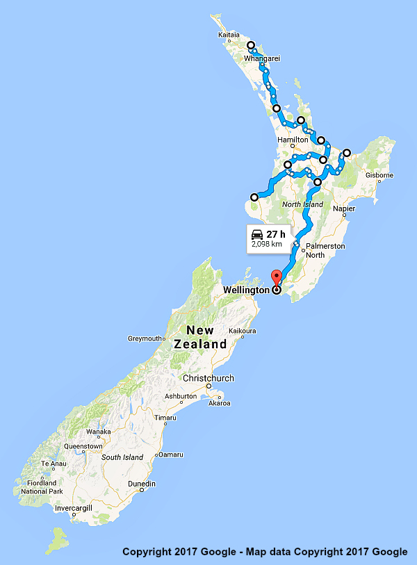 |
North Is. Highlights 15 Days 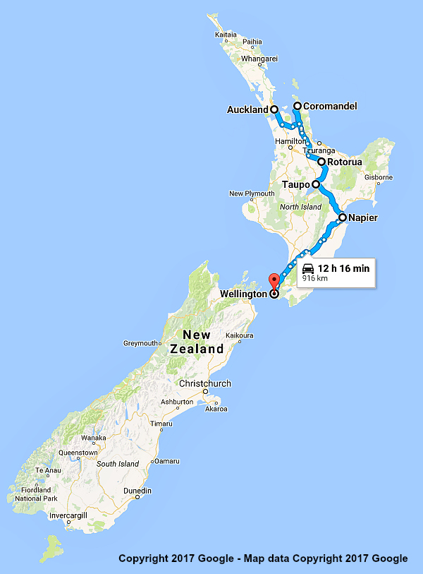 |
Lower North Is. 15 Days 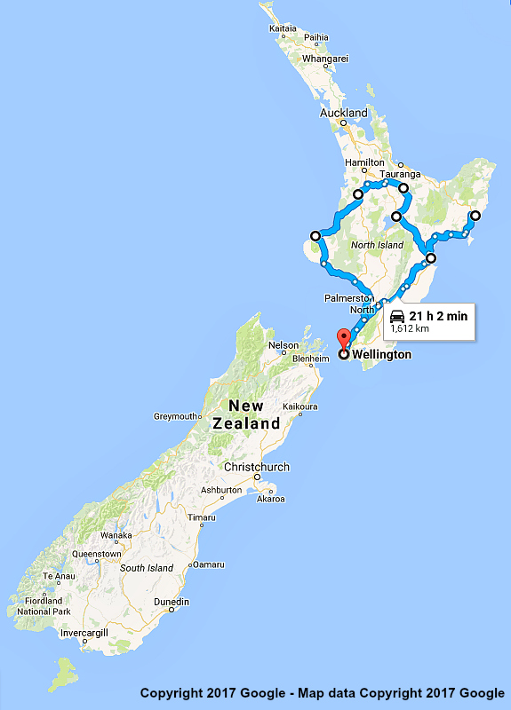 |
Upper North Is. 15 Days 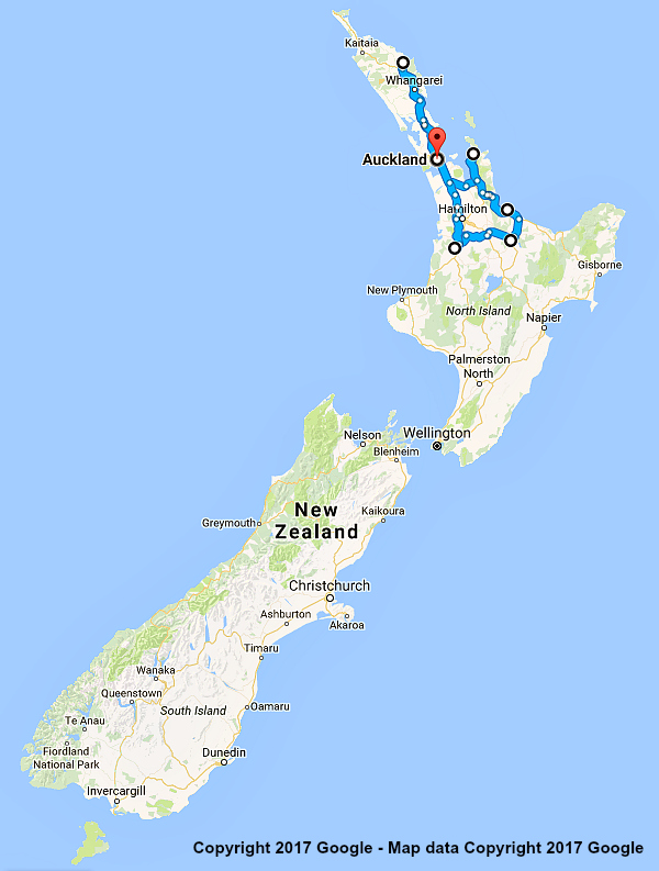 |
|
Lower North Island 10 Days  |
Upper North Is. 10 Days  |

