BEST VIEWED IN LANDSCAPE MODE ON MOBILE DEVICES
U.S.FTC GUIDELINES PLEASE NOTE: we act as an affiliate for several companies that feature on our website. In some cases we may earn a commission from referrals to those companies. For further information please refer to our Privacy and Disclaimer policies which can be found in the "US" tab.
U.S.FTC GUIDELINES PLEASE NOTE: we act as an affiliate for several companies that feature on our website. In some cases we may earn a commission from referrals to those companies. For further information please refer to our Privacy and Disclaimer policies which can be found in the "US" tab.
Here are a selection of helpful maps of New Zealand.
We hope that these maps of New Zealand provide a variety of useful information for you.
For detailed PDF maps of each region click HERE.
New Zealand is an island country located in the south western Pacific Ocean, and is primarily made up of two large islands, commonly known as the North Island, and the South Island.

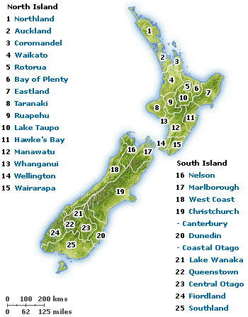
New Zealand is made up of 25 unique regions, stretching from the "creatively" named Northland, at the top of the North Island, to "Southland" at the base of the South Island.
New Zealand has a widely variable terrain, and includes everything from beautiful surf beaches, to snow covered alps and glaciers. The northern regions have an almost sub-tropical climate, whilst the southern regions are cooler and may experience very cold winters. Snow can fall on both islands, and remains permanently on the alps.

State Highways (maps courtesy NZ Tour Maps - click the map to visit their website)


Interactive Google Map
Left click, hold and drag to move around map.
Use the "+" and "-" buttons to zoom in or out.
Use this map to search for locations in New Zealand - just click on "Directions" then type in your desired location
View Larger Map
New Zealand Regions
Click on the Region's name to view lots of information about that region.


Our thanks to Tourism New Zealand for the climate maps reproduced here
To learn more about the regions shown on these maps of New Zealand, click here.

